
This app is perfect for offroad and competition driving, motorcycle racing and 4×4 rallying.
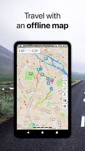
OFFLINE VECTOR MAPS
• Incredibly detailed high quality maps covering the whole world.
• Based on OpenStreetMap.org data and takes up very little space.
•The fastest vector map works perfectly even on the oldest devices.
• Map updated monthly with the most recent fixes and additions.
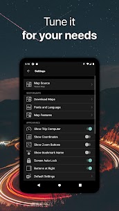
• Adjustable label size – large labels on maps are extremely useful while driving.
•Select the objects currently visible on the map.
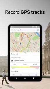
OFFLINE NAVIGATION
• Best alternative to portable GPS navigator for route finding, GPS track recording and waypoint marking.
• Detailed routes with voice instructions in 9 languages, even when you are offline.
•Shortest routes perfect for the way you travel – driving, cycling, walking with the option to avoid certain parts of the route (toll roads, highways, ferries, unpaved roads, hills, stairs).
• If you miss a turn, automatic rerouting allows you to resume your journey or find a new route to your destination.
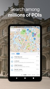
OFFLINE RESEARCH
• Incredibly fast – results appear instantly as you type.
•Search in different ways – by address, object name, category or even by GPS coordinates.
• Searches in multiple languages simultaneously, making searching easier than ever.
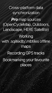
SYNCHRONIZATION
• Seamlessly sync your data across multiple iOS / Android devices as long as they are authorized with the same account.
• All data such as saved places, saved GPS tracks and created routes will be synchronized across all your devices on both operating system platforms
SUPPORTED FILE FORMATS:
.GPX, .KML, .KMZ for GPS tracks, bookmarks and routes,
.MS, .XML for personalized map sources,
.SQLiteDB, .MBTiles for offline raster maps,
.GeoJSON and MapCSS for vector overlays.
Continued use of GPS running in the background can dramatically reduce battery life.