Recce – Planning & Orienting v2.2.18 Paid Mod
Images


Description
A portable GPS and calculator in one app. Built with Maps SDK and Fused Location API for high accuracy and low power consumption, suitable for long expeditions.
Features:
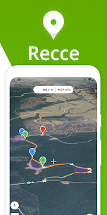
🗺 Map
• Instant update of coordinates and grids.
• Pins: mark points on the map and save them.
• Routes: Draw lines and place checkpoints to mark a route.
• Zones: join the endpoints of a route to demarcate an area.
• Geodesic distance: The lines drawn on the map are geodesic and indicate the shortest path between 2 points on the Earth’s surface.
📍 Pins (or markers)
• Organize and categorize saved items by groups and colors.
• Manage saved pins, routes and areas by sorting and deleting.
• Add multiple pins to the ruler sequentially.
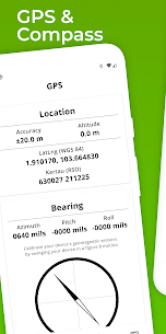
🛰GPS
• Provides your current location using the Fused Location API for greater accuracy at lower power consumption.
• Provides your bearing using your device’s position sensors
• Graphical compass for navigation and orientation with support for any orientation/rotation.
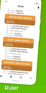
📐 Ruler
• Measures distances and bearing between Pins.
• Supports multiple pin additions for cumulative measurements.
• Add routes and areas to measure distances and straight line direction between each control point.
Coordinate Systems:
🌐 Recce supports the following systems:
1. WGS84 latitude and longitude
2. UTM, all areas
3. MGRS (in UTM coverage only)
4. Kertau (RSO) / RSO Malaysia (m)
5. UK National Network (BNG)
6. Maidenhead Locator System (QTH Locator)
Note 1: The application respects each system’s area of use and returns “N/A” in locations outside the system boundaries.
Note 2: The app does not support UPS (universal stereographic polar) and it is not planned to do so.
Disclaimer:
Reconnaissance is not affiliated with any military organization or armed force. All formulas and information in the application are obtained from freely available sources such as the EPSG repository and guide.
What's new
v2.2.1
New features:
1. Imperial units and nautical miles for distances and areas
Bug fixes:
1. Fixed parsing of UTM coordinates with 7-digit northings.