OsmAnd+ Offline Maps Travel & Navigation v4.2.0 Unlocked Mod
Images
Description
OsmAnd + (OSM Automated Navigation Directions) is a mapping and navigation application with access to free, global, high-quality OpenStreetMap (OSM) data.
Enjoy voice and optical navigation, viewing POIs (points of interest), creating and managing GPX plots, viewing contour lines and altitude information, choosing between modes driving, cycling, pedestrian, OSM edition and much more.
OsmAnd + is the paid version of the app. By purchasing it, you support the project, finance the development of new features and receive the latest updates.
Some of the main features:
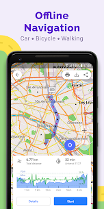
Navigation
– Step by step voice guidance (recorded and synthesized voices)
– Optional lane guidance, street name display and estimated time of arrival
– Supports intermediate points on your route
– Automatic rerouting whenever you deviate from the route
– Search for places by address, by type (ex: restaurant, hotel, gas station, museum) or by geographic coordinates
– OSM public transport
Map display
– Show your position and orientation
– Optionally align the image according to the compass or the direction of your movement
– Save your most important places as favorites
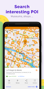
– Display the POIs (points of interest) around you
– View specialized inline tiles, satellite view (from Bing), different overlays such as tour / navigation GPX tracks and additional layers with customizable transparency
– Optionally display place names in English, local spelling or phonetics
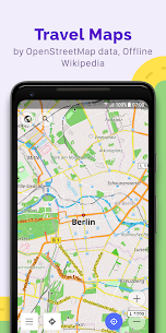
Use OSM and Wikipedia data
– High quality information from the best collaborative projects in the world
– OSM data available by country or region
– Wikipedia POIs, perfect for sightseeing
– Unlimited free downloads, directly from the app
– Compact offline vector maps updated at least once a month
– Selection between full regional data and road network only (example: all of Japan is 700MB or 200MB for road network only)
Safety devices
– Automatic day / night view switching as an option
– Display of the optional speed limit, with a reminder if you exceed it
– Optional speed dependent zoom
– Share your location so your friends can find you
Characteristics of bicycles and pedestrians
– Display of hiking, walking and cycling trails, ideal for outdoor activities
– Special routing and display modes for bikes and pedestrians
– Optional public transport stops (bus, tram, train) with line names
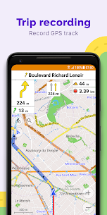
– Optional trip recording to local GPX file or online service
-And Optional speed and altitude display
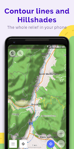
– Display of contour lines and shading (via an additional plugin)
Public transport
– Navigation in public transport: Metro, Bus, Tram, etc.
Contribute directly to OSM
– Report data bugs
– Download GPX tracks to OSM directly from the application
– Add POIs and upload them directly to OSM (or later if offline)
– Optional trip recording also in the background (when the device is in standby mode)
OsmAnd is open-source and under development. Anyone can contribute to the app by reporting bugs, improving translations, or coding new features. The project is in a living state of continuous improvement through all these forms of interaction between developers and users. The progress of the project also relies on financial contributions to finance the coding and testing of new features.
Approximate map coverage and quality:
– Western Europe: ****
– Eastern Europe: ***
– Russia: ***
– North America: ***
– South America: **
– Asia: **
– Japan and Korea: ***
– Middle East: **
– Africa: **
– Antarctica: *
Most countries around the world are available for download!
From Afghanistan to Zimbabwe, from Australia to the United States. Argentina, Brazil, Canada, France, Germany, Mexico, United Kingdom, Spain, …
Important! Older versions of OsmAnd: 2.1.2 and 1.9.7 use the permission of the device administrator for the “Activate screen” function. The resolution allows OsmAnd to light up the screen before rotating while browsing.
What's new
• Cloud backup
• Added night mode for "Topo" rendering style
• Added option to download Contour lines in feet
• Tracks can now be colored by altitude, speed, or slope.
• Updated "Trip recording" dialog
• Distance by tap moved from the Radius ruler into a separate option
• Plan Route: added ability to change navigation options, accessing configure map and search without leaving plan route
• Added option to change the route line appearance.