Map Coordinates v5.4.1 Full Mod Pro
Soft Stack Dev
September 10, 2021
9.1MB
Latest
5.0 and up
Images


Description
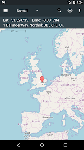
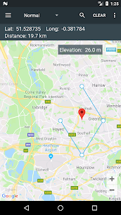
A simple tap on the map gives you access to global coordinates. In addition, Map Coordinates offers a full set of tools such as distance measurement, current GPS position, history / favorite locations, location sharing, finding a location or copying locations. contact details / address. You can switch between several types of coordinates like decimal degrees, DMS (degrees, minutes and seconds) or even special types like what3words, MGRS, UTM or GEOREF.
The app is designed to easily determine the coordinates and address of a point on the map and share them with friends via SMS, email or social apps.
When you need to find a location, you can either type / paste the address / coordinates into a search field or enter each coordinate value one by one into its own field using the advanced search options. what3words, MGRS, UTM or GEOREF can only be searched using the single search field.
The current GPS position is best received when the mobile device is located outdoors. GPS satellites are easy to find when there is no interference like buildings or clouds. Even if the device is located indoors, the location can be found accurately through the WiFi network, but only if the device is connected to this network.
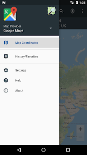
The side drawer menu is used to navigate between different parts of the app like history / favorites, but it is also used to change map provider. The map providers available are Google Maps and Open Street Maps, each with different types of maps. Under Open Street Maps, a compass is also available at all times.
The settings are also accessible from the side navigation drawer. There you have the option to switch between existing coordinate types, change the visibility of the address bar, or activate the distance measure tool and the elevation tool. Elevation displays the elevation of the selected location on the map.
Remarks:
1. GPX and KML file types are supported with some limitations: only simple waypoints are processed for GPX files, and only marks are processed for KML files.
2. The UTM, MGRS and GEOREF coordinate types are available as paid options
We hope this app meets your needs, but if you have any other expectations, please do not hesitate to contact us and we will try to help you.
What's new
- Minor issues were fixed
MOD INFO:
MGRS coordinates type unlocked;
UMT coordinates type unlocked;
Remove Ads unlocked;
Measurement Tools unlocked;
Disabled / Removed unwanted Permissions + Receivers + Providers + Services;
Optimized and zipaligned graphics and cleaned resources for fast load;
Ads Permissions / Services / Providers removed from Android.manifest;
Ads links removed and invokes methods nullified;
An Ads layouts visibility disabled;
Google Maps Location works;
Google Play Store install package check disabled;
Debug code removed;
Remove default .source tags name of the corresponding java files;
Analytics / Crashlytics / Firebase disabled;
No active trackers or advertisements;
Languages: Full Multi Languages;
CPUs: armeabi-v7a, arm64-v8a;
Screen DPIs: 120dpi, 160dpi, 240dpi, 320dpi, 480dpi, 640dpi;
Original package signature changed.