Locus Map Pro – Outdoor GPS Navigation and Maps v3.65.0 Paid Mod
Asamm Software s. r. o.
September 23, 2021
42 MB
Latest
5.0 and up
Images
Description
An ultimate navigation app for all outdoor enthusiasts – hikers, mountain bikers, mountaineers, trail runners or geocachers. And not just for them, but Locus Map Pro is also widely used by professionals – explorers, travelers or rescue teams all over the world.
Locus Map Pro offers true multi-functionality and flexibility:
– advanced navigation capability, supporting both online and offline routing services
– an unprecedented choice of premium offline and online cards
– advanced mapping tools – map overlays, offsets, support for WMS sources
– tools for monitoring sports activities – tracking, audio coach, graphics, statistics, support for external sensors (GPS, HRM, cadence, etc.)
– 24/7 global weather forecast
– sophisticated geocaching tools • graphical and calculation tools, online / offline logging, support for trackables, Pocket Queries, spoilers, etc.
Wallet card
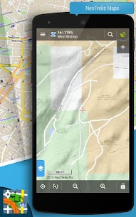
Offline maps
– LoMaps – OSM based vector maps of the world. Containing themes for hiking, biking, winter sports, road or city – three LoMaps are free
– Maps from renowned cartographic publishers:
– Germany, Austria, Italy – Kompass, Outdooractive Summer and Winter, Freytag-Berndt hiking maps
– United States – Accuterra Trail Maps
– Switzerland – SwissTopo
– United Kingdom – Ordnance Survey (equivalent to Landranger and Explorer)
– France – survey and IGN satellite
– Spain – CNIG
– Poland – Compass hiking maps
– Czech Republic, Slovakia – SHOCart
– other countries – PZS Slovenia, IGN Belgium, Cartographia Hungary, etc.
– support for external cards in SQLite, TAR, MBT, GEMF, Orux or RMAP formats
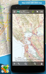
Online Maps
– World – various maps based on OSM
– United States – USGS, ChartBundle
– Europe – Outdooractive Summer and Winter, Freytag-Berndt, IGN France and Belgium, Kapsi.fi, Turistautak, Cartographia, Skoterleder, Statkart, Retromap (Russia), UMP and Osmapa.pl (Poland) and many others
– Asia etc. – GSI (Japan), Visicom (former Soviet countries), Navigasi (Indonesia), NzTopoMaps (New Zealand) …
Most online maps can be downloaded for offline use.
WMS Cards
– weather maps, NASA maps, cadastral maps …
Characteristics:
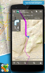
Navigation and guidance
– Detailed voice navigation with support for online / offline routing services
– direct guidance to a point (on the map or on the compass) or along a route with notifications
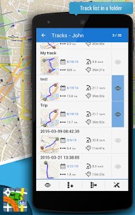
Trails and routes
– multi-profile track recording
– graphics and statistics
– audio coach for effective training
– Support for external Bluetooth / ANT + sensors – HRM, speed / cadence, GPS, NMEA
– route planning and editing tools
– import / export of routes / tracks from / to various formats (KML, KMZ, GPX …) and web services (Strava, Runkeeper, Google Earth, etc …)
– Customizable bike computer dashboard
Points
– creation of its own database – filtering, search, sorting
– import / export in many formats, support for web services
– LoPoints – OSM POI database
Cartographic tools
– map overlay, calibration and offsets
– support for various external map formats and coordinate systems
– support for geotagged photos, OSM notes
To look for
– online and offline addresses
– W3W addresses
– LoPoints, GeoNames, GNS and Wikipedia
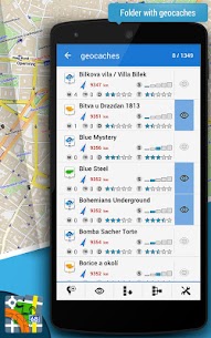
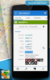
Geocaching
– download geocaches via the Geocaching4Locus add-on
– offline and online logging
– support for waypoints, PocketQuery, trackables, spoilers
– graphics and calculation tools
Live tracking
– private or public sharing / monitoring of the location in real time
Other features and tools
– parking assistant, world weather forecast, QR code generator …
Locus Map Pro is highly customizable. Everything can be set according to user needs – main menu, function panels, dashboards, custom screens … The functionality of the application can be further extended by many additional modules – Locus Map Watch, Pebble, RFLKT (connection with portable devices), augmented reality, GeoGet, Munzee, etc.
This app uses the device administrator permission.
What's new
*** Version 3.54+ ***
chg: simplified "Disable lock screen" system
and the huge list of other changes...